BIKE TRIPS IN THE NEIGHBOURHOOD
We are avid bikers and love exploring the Valley on our bikes. Below are some suggestions from our favourite trips. The difficulty is based on average fitness riding standard bike and duration times are net of any longer stops. If you are not bringing your bikes, we offer a selection of standard and e-bikes for rent right from our place. Enjoy the ride and let us know how did you like it thereafter!
RADICOFANI
LENGTH: 38 KM (100% asphalt)
DIFFICULTY: medium-difficult
TIME: 3-4 hours (2 hours as a sport or using E-bike)
This track takes you to climb Radicofani – the medieval castle dominating the valley with 900 m elevation (reminding some of us of the famous elephant-in-the-snake drawing from Little Prince).
The road there is mostly flat, except for the last few kilometers when one needs to climb 500 meters in height. Refresh yourself in Radicofani, potentially climb up the castle.
On the way back, get ready for the exclusive scenery, riding a hill-top road with Amiata on your left and Val d’Orcia all around you. If you get lucky, you will meet some horses and sheep close to the road.
There is also an option to extend the trip by plunging into the natural pools of Bagni San Filippo (extra 6km)
While the road is mostly comfortable with asphalt, there are virtually no cars.

WHITE ROADS AROUND PIENZA I.
LENGTH: 38 KM (75% asphalt), 47 km via Monticchiello and La Foce
DIFFICULTY: Medium (base trip), Difficult (extended option)
TIME: 2,5 - 3,5 hours (2 hours as a sport or using E-bike)
This track takes you on the white roads around Pienza. The climb up from Spedaletto is moderately difficult, but well worth the effort as Pienza is nicely nested right in front of you all the way. You can enjoy your well-deserved rest on the city ramparts with a glass of prosecco.
Going back, you take another scenic white road (take sharp left just when you leave Pienza’s gate towards Radicofani), with views of Monticchiello and winding roads around. The fit ones can enhance their trip with strenuous climb up to the little town and rest there under the figs trees of La Guardiola restaurant.
If that’s still not enough for you, take the asphalt road in the direction of Montepulciano (not the white road that leads there as well) and after cca. 5 km turn right on the white road to La Foce. Enjoy the down-hill ride back home!

WHITE ROADS AROUND PIENZA II.
LENGTH: 44 KM (60% asphalt)
DIFFICULTY: medium
TIME: 2,5-3 hours (2 hours as a sport or using E-bike)
This track takes you on the white roads around Pienza. The climb up from Spedaletto is moderately difficult, but well worth the effort as Pienza is nicely nested right in front of you all the way. You can enjoy your well-deserved rest on the city ramparts with a glass of prosecco.
From Pienza, ride in the direction of San Quirico, but turn left on a white road shortly (500 m) after the Agristoro La Fonte. This winding white road takes you through the typical rolling hills of Val d’Orcia with some of the best views of Pienza.
It also winds close to the Vitaleta chapel, one of the most photographed spots in Tuscany – if you want to stop by, you need to take an unmarked path to the right approx. after 1 km on the white road.
Once you get back on the asphalt road, it’s all flat back home.

AROUND LA FOCE
LENGTH: 15 KM (70% white roads)
DIFFICULTY: easy-medium
TIME: 1,5 hour (1 hour as a sport or using E-bike)
This is a short track, with a rather steep hill to climb on a white road – but if you opt for the e-bike, you will make it with just a little sweat.
From Chiancianello you ride around the beautiful 13th century Torre Tarugi and up the white road. This is steep, but once you have reached the road leading from La Foce to Castiglioncello del Trinoro, it’s over and you are in for a nice ride along the level line overseeing the valley.
At La Foce, you join the asphalt road and ride down enjoying the curvy road. You can stop for a refreshment or a coffee at our favourite Dopolavoro restaurant. And you are back home in no time!
If you want to avoid a bit busier asphalt road from La Foce, you can turn left at Chiarentana and head down on a white road (follow Sassaia signs near Chiarentana)

WHITE ROAD TO CASTEL TRINORO & LA FOCE
LENGTH: 29,6 KM (70% white roads)
DIFFICULTY: medium-difficult
TIME: 2 -2,5 hours (1,5 hours as a sport or using E-bike)
This is an extension of the La Foce circle that would take you through roads less traveled, with a rather steep and long hill to climb on a white road. The beauty is that you will have long vistas and no cars around - I bet that you will not meet 5 cars along the journey.
From Chiancianello you ride around the beautiful 13th century Torre Tarugi and continue for about 7 km along the asphalt road towards Radicofani. With a sign for Sarteano to the left, the road will change into gravel surface but well-maintained. The ascent (7 km) is gradual at the beginning but the last 3 kms will test even the electric bikes. Make sure you take time to enjoy the wilderness as we have met deers or fox on multiple occasions.
At the top, take left to Castiglioncello del Trinoro (a fine boutique hotel like a bird nest over the valley). If you thought the road up was difficult, be prepared for a rather steep, technical decline for about 2 km. But then it’s over and you are in for a nice ride along the level line overseeing the valley.
At La Foce, you join the asphalt road and ride down enjoying the curvy road. You can stop for a refreshment at our favourite Dopolavoro restaurant. And you are back home in no time!

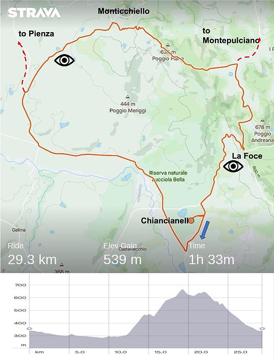
AFRICA IN VAL D'ORCIA
LENGTH: 29,3 KM (90% asphalt)
DIFFICULTY: medium-difficult
TIME: 2 -2,5 hours (1,5 hours as a sport or using E-bike)
We named the circle because of its shape but on occasions one could encounter some wild animals. You can think of the circle in thirds - one third flat, one third up the hill and last part is down.
The flat part goes along the road to Pienza all the way to the crossing where the road to Monticchiello splits to the right. It should be a nice warmup before the long winding road uphill. The steep sections, and hence lower speeds, allow you to actually enjoy the countryside and the views more. You will have the gems of Pienza walls and Monticchiello borgo all the time in your sight.
If you want to stop for a refreshment, climb all the way up to our favourite bistro Guardiola nestled below the Monticchiello's walls. Otherwise take a right turn at the beginning of the village in the direction of Montepulciano and after a short decline you will see a beautiful winding cypress road - going up again.
After about 1,5km from the pass in the forest do not forget to take the right turn onto a gravel road direction La Foce/Castellucio for about 3 km. From there it's only down to home!
NORTHERN RIM OF VAL D'ORCIA
LENGTH: 43,5 KM (70% asphalt)
DIFFICULTY: medium-difficult
TIME: 2,5 -3,5 hours (2 hours as a sport or using E-bike)
This circle in principle combines La Foce and Africa circles (but this one in the opposite direction) and allows you to stay at the northern rim of the valley, enjoying the views without going up and down all the time. But do not be mistaken, there are still some hills to climb.
At the beginning, you do the heavy lifting going up to la Fornace (take left after the Torre Tarugi). Once up you can start enjoying the views from high above. If you have not taken the picture of the picturesque winding cypress road, our favourite spot is just bellow the walls of the La Foce settlement.
Around Monticchiello, there are multiple options to get to Pienza, we rode the flattest one in terms of elevation changes. Make sure you keep your eyes open as there are other 2 winding cypress roads around, one of them you actually ride down.
Along the circle you can stop along multiple "pit stops"to refresh yourselves - we recommend a coffee at Dopolavoro/La Foce, glass of white wine under the fig trees in La Guardiola/Monticchiello and complete energy refill with hearty meals at our friend Antonio in Agristoro Poderucio below Pienza. From there it is an easy ride home.

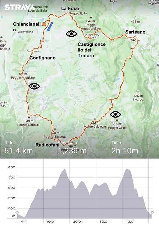
SOUTHEASTERN RIM OF VAL D'ORCIA
LENGTH: 51,4 KM (80% asphalt)
DIFFICULTY: difficult
TIME: 3-4 hours (2 hours as a sport or using E-bike)
This circle in principle combines the Radicofani (but this time in the opposite direction) and Trinoro circles and allows you to stay above 500 m height along the southeastern rim of the valley. But is not an easy ride as you will climb more than 1200 meters in elevation.
At the beginning, you do the heavy lifting going up to Radicofani along one of the most scenic roads (literally riding on the ridge with steep ravines underneath you). Once up you can start enjoying the views from high above or climb all the way to the fortress.
From Radicofani you will take winding road down-up-down to Sarteano, changing quickly the scenery between deep forests and views towards Val d'Orcia and towards Lazio region with Lago Bolsena in a distance.
From Sarteano - where you could refresh yourselves at the corner bar or have lunch at our favourite Da Gagliano osteria - take the winding road up towards Castiglioncello del Trinoro. There are actually two options here: one steep down towards Foce-Fornace road that will give you great views, or take a right turn before Trinoro towards Pietraporciana picnic area, which will ultimately lead to La Foce through the forest.
Once at La Foce, you are almost home!